Demosites
Africa
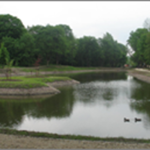
ANKERKEHA RIVER SUB BASIN-BASED RESTORATION OF LAKE HAYQ THROUGH ECOHYDROLOGY
- The project operates at the catchment scale of the Ankerkeha River Sub-basin to address the root causes of the lake's degradation, such as soil erosion and land use.
- The Ankerkeha River is the main feeder to Lake Hayq, and interventions like riverbank restoration with bamboo are implemented to reduce sediment load.
- The core site is Lake Hayq, a highland freshwater lake suffering from sedimentation and habitat loss, targeted for restoration using Ecohydrology principles.
- The project enhances erosion prevention and habitats for species through landscape restoration. It maintains food (fishery, horticulture) and fresh water provision, alongside cultural and tourism services.
Demosite Location
Country: Ethiopia
Contact
- Name: Assefa Tessema Tecklie
- Email: atecklie2018@gmail.com
- Organization: Wollo University
- Website:
CAPACITY BUILDING IN ECOHYDROLOGY AND PROMOTION OF ECOHYDROLOGY DEMONSTRATION SITE PRACTICES ON RIBB WATERSHED & LAKE TANA SHORE
- Ribb watershed is located in Lake Tana Sub Basin, NW part of Ethiopia, in Amhara Regional State. Ribb watershed has a total drainage area of 1790 km² and the main Ribb river is about 129.7 km long, flowing towards the west until it reaches Lake Tana.
- The watershed demonstrates severe land degradation. The problem has been long aged and deep rooted, as the watershed is one of the aged agricultural areas. The long aged agricultural activities resulted in progressive depletion on resources through haphazard deforestation, overgrazing and over cultivation and hence sever soil erosion and land degradation.
- This project aims to establish a UNESCO Biosphere Reserve at Lake Tana -For People & Nature.
Demosite Location
Country: Ethiopia
Contact
- Name: Yohannes Z. Negussie
- Email: yhnnszerihun@gmail.com
- Organization: Ministry of Water, Irrigation and Energy, Addis Ababa
- Website: http://www,mowr.gov.et
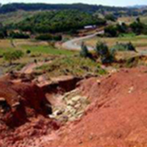
ECOHYDROLOGY SYSTEMIC SOLUTION FOR RESTORATION OF THE BURKITU RESERVOIR AS AN ALTERNATIVE WATER SUPPLY SOURCE FOR THE ASELLA CITY POPULATION (ETHIOPIA)
- Located in Oromia Regional State, inside the Ashebeka river basin in Ethiopia. The Asella town is situated 175 km south-east of Addis Ababa on a sloping plateau between Mt. Chilalo and the Rift Valley escarpment.
- The Asella Lake’s (or Burkitu Reservoir with earth fill dam gross capacity of 250,000 m3) usage has been abandoned since it caused disease among the people from its high rate of dioxin pollution (fig.1).
- This project is in cooperation with MoWIE (Ministry of Water, Irrigation and Energy of Ethiopia).
Demosite Location
Country: Ethiopia
Contact
- Name: Yohannes Z. Negussie
- Email: yhnnszerihun@gmail.com
- Organization: Ministry of Water, Irrigation and Energy, Addis Ababa and European Regional Centre for Ecohydrology
- Website: http://www.mowr.gov.et/
ECOHYDROLOGY AS THE FRAMEWORK FOR SUSTAINABLE UTILISATION OF WATER IN THE NAIVASHA BASIN (KENYA)
- Lake Naivasha (fig. 1) is the second largest freshwater lake after Lake Victoria in Kenya. Drainage from two perennial rivers, the Malewa (Nyandarua Mountains) river and the Gilgil river (Rift Valley escarpment ridges).
- Lake Naivasha is surrounded by the major source of cut flowers and vegetables in Kenya (productivity of export crops: 1,4-2,1 t per year).
- This project is funded by European retailer buyers of flowers from Lake Naivasha and additionally, Lake Naivasha is a RAMSAR site since 1995 (over 300 species of birds).
Demosite Location

Country: Kenya
Contact
- Name: David Harper
- Email: dmh@le.ac.uk
- Organization: University of Leicester
- Website: http://www.le.ac.uk/
WESTERN AREA PENINSULA WATERFUND (SIERRA LEONE)
- The demo site comprises of a Lake at the Guma Valley Water Company Dam and more 50 water catchments in the Western Area Peninsula Water Catchment. The water catchments are characterised by several streams originating from the mountains and flows down to the Atlantic Ocean passing through wetlands. The Atlantic Ocean almost surrounds the mountainous water catchments.
Demosite Location
Country: Sierra Leone
Contact
- Name: Ishmail Kamara
- Email: ish83ish@yahoo.com
- Organization: National Water Resources Management Agency
- Website:
E-FLOWS SCIENCE IN THE CROCODILE RIVER AS PART OF THE INCOMATI TRANSBOUNDARY BASIN, SOUTHERN AFRICA. MOZAMBIQUE
- Perennial, highly seasonal river site with social and ecological value, located within the Kruger National Park in South Africa, upstream of Mozambique.
Demosite Location
Country: South Africa
Contact
- Name: Gordon O’Brien
- Email: gordon.obrien@ump.ac.za
- Organization: University of Mpumalanga
- Website:
Arab States
AL MAYDANEH PLAIN WETLAND (MPW), LEBANON
- A seasonally saturated agricultural plain wetland within a semi-arid basin, fed by springs, runoff, and groundwater, focused on ecohydrological restoration and climate resilience.
- Enhanced: Waste-water treatment, flood moderation, and erosion prevention are improved via constructed wetlands and MBBR systems. Maintained: Food provision, freshwater supply, and habitat support are sustained through climate-resilient farming and water management.
Demosite Location
Country: Lebanon
Contact
- Name: Amin Shaban
- Email: geoamin@gmail.com
- Organization: The Lebanese Center for Water and Environment (LCWE)
- Website:
NATURAL MITIGATION AND REMEDIATION OF WATERSHEDS AND LAGOON ECOSYSTEMS OF GHAR EL MELH (TUNISIA)
- It is a natural lagoon located North-East of Tunisia on the Mediterranean coast. It is the only remnant of the former Gulf of Utica. The direct impact of all this is the increase of the speed of the coastal erosion, as the main sources of sand to the coast are closed. The average coastal erosion rate is between 5 and 20 m per year, according to the different places. There is no more link between the Medjerda River and the lagoon. The catchment linked to the lagoon is very limited as it is surrounded by some hilly terrain. Thus only some very small tributaries are coming from the West, mainly filled by the waste waters of small agricultural areas and villages (Kalaat al Andalous, Bajou), with no measurable discharge. And the North side is very steep with no river, but the waste waters of the city of Ghar el Melh directly reach the lagoon, with no treatment.
Demosite Location
Country: Tunisia
Contact
- Name: Oula AMROUNI
- Email: oula.amrouni@gmail.com
- Organization: Institut National des Sciences et Technologies de la Mer
- Website:
Asia and the Pacific
DEVELOPING FIT-FOR-PURPOSE TOOLS TO ADDRESS COMPLEX SOCIAL, ECOLOGICAL AND ECONOMIC ISSUES IN WATER PLANNING (THE MURRAY-DARLING BASIN, AUSTRALIA)
- The River Murray is the life blood of the 1,7 million inhabitants South Autralian population and its economy. The area stretches from the river channel from the Victorian border including Lakes Alexandrina and Albert.
- The Murray-Darling Basin is Australia’s most important agricultural region accounting for over 39% of Australia’s gross value in agricultural production.
- There are 16 RAMSAR significant sites as in particular, Chowilla Floodplain, the River Channel, the Coorong and Murray Mouth.
Demosite Location

Country: Australia
Contact
- Name: Poh-Ling Tan
- Email: p.tan@griffith.edu.au
- Organization: Griffith Law School
- Website: https://www.griffith.edu.au
DEVELOPING SOLUTIONS FOR ENVIRONMENTAL-FRIENDLY WATER MANAGEMENT IN PERI-URBAN LANDSCAPES(WESTERN SYDNEY, AUSTRALIA)
- The HawkesburyNepean catchment area runs from Lake George in the South, to beyond Lithgow out west, follow the foothills of the Blue Mountains into the Hawkesbury region and pours out to sea at Broken Bay.
- The South Creek catchment (fig.1) provides water services to its inhabitants and dwellings which are expected to increase respectively by 40% and 25% from 2011 to 2030.
- The UNU Regional Centre of Expertise on Education for Sustainable Development (Greater Western Sydney) has research groups focused on the studies of the site.
Demosite Location

Country: Australia
Contact
- Name: Professor Basant Maheshwari
- Email: b.maheshwari@westernsydney.edu.au
- Organization: Western Sydney University
- Website: http://www.uws.edu.au/
FENGXI SPONGE CITY (CHINA)
- Fengxi Sponge City is located in the Fenghe catchment, Shaanxi, northwestern arid area of China, with a total area of 143.17 km2 and a population of 169,308.The central 22.5 km2 is the sponge pilot area
- Five core strategies to promote sponge city construction: 1. Based on source control and outflow regulation, make rainwater be purified and absorbed on-site as much as possible; 2. Make buildings and green spaces interactive integration, combine storage with drainage to prevent and govern waterlogging; 3. Watershed collaboration, consideration of both recent and future, and systematic management of water pollution; 4. Blend blue (river)-green (plant space) zones, and guarantee both flood control and ecology protection; 5. Make full use of unconventional water resources, reduce the use of conventional water, and solve the water shortage problem in northern China.
- In a sponge city, stormwater is absorbed, stored, infiltrated, and purified when it rains. It endeavors to restore its pre-development ecohydrological regime and to reduce natural hazards within the urban basin.
- water quality of Fenghe river and Weihe river crossing the pilot area respectively reaches class Ⅲ and Ⅳ (GB3838-2002,China) on the whole.
Demosite Location

Country: China
Contact
- Name: Prof. Dr. Jun XIA
- Email: xiajun666@whu.edu.cn
- Organization: Chinese Academy of Sciences ,Beijing, China
- Website: http://www.fcfx.gov.cn/info/iIndex.jsp?cat_id=10750
LINKAGE OF WETLAND ECOLOGY AND HYDROLOGY WITH THE SUPPORT OF INFORMATION TECHNIQUES FOR ASSESSING THE DEGRADED INLAND FRESHWATER WETLAND HABITAT IN SANJIANG PLAIN (NORTHEAST CHINA)
- The Honghe region is located in the northeast Sanjiang Plain in Heilongjiang Province including four portions: the Honghe National Nature Reserve (HNNR) and three farms. The Sanjiang Plain has the most representative density of inland freshwater wetlands in China.
- 90% of marsh wetland has been lost from 1975 to 2006 and its area declined sharply around the three main farming businesses of the demosite which intensively use water from wetlands and groundwater.
- HNNR is listed in the Ramsar Convention with High Biodiversity Status.
Demosite Location

Country: China
Contact
- Name: Huili GONG
- Email: maggie2008zj@yahoo.com
- Organization: College of Resources Environment and Tourism (CNU)
- Website: http://english.neigae.cas.cn/
MANAGEMENT OF REGIONAL WATER RESOURCES LINKED WITH MAINTAINING OF WETLAND BIODIVERSITY IN THE SUBURBAN AREA OF METROPOLITAN BEIJING (CHINA)
- The Yanking district includes river Hai catchment which lies in the plain suburban area in Beijing. Guishi river goes into the Guanting Reservoir which lost its main function of water supply due to water quality degradation.
- The groundwater supports nearly 70 % of the total water resources for local use and thus the regional mean groundwater depth decreased by 1,52m in 20 years.
- Wild Duck Lake Wetland became a natural reserve area in 2000. It is an important habitat for migratory birds (fig1).
Demosite Location
Country: China
Contact
- Name: Demin Zhou
- Email: zhoudemin@neigae.ac.cn
- Organization: College of Resources Environment and Tourism (CNU)
- Website: http://english.neigae.cas.cn/
OPTIMIZED AGRICULTURE ACTIVITY IN RESPONSE TO RESERVOIR HYDROLOGICAL OPERATION TO REDUCE NUTRIENTS INPUT AND INCREASE THE WATER QUALITY IN THE THREE GORGES RESERVOIR (CHINA)
- Pengxi River, a tributary of the Yangtze, in the Three Gorges Reservoir, a high impacted ecosystem
- China Three Gorges Reservoir, the largest one in China. Large scale seasonal operation for hydropower production and flood control
- Water supply; Agriculture; Biological primary production; Biodiversity maintenance; Environmental purification
Demosite Location

Country: China
Contact
- Name: Zhe LI
- Email: lizhe@cigit.ac.cn
- Organization: Key Laboratory of Reservoir Environment, Chongqing Institute of Green and Intelligent Technology, Chinese Academy of Sciences
- Website:
PARTICIPATORY ECOHYDROLOGICAL GOVERNANCE AND PRACTICES TO INCREASE WATER VALUES IN HONGFENG LAKE AREA IN GUIZHOU PROVINCE (CHINA)
- It is the largest karst artificial lake in the Guizhou plateau at present. It has a total area of 5567.34 hectares
- Drinking water to Guiyang City with a population of over 3 million, hydropower, flood control, shipping, recreation, and commercial aquaculture are main functions of the lake
Demosite Location

Country: China
Contact
- Name: Yufeng LUO
- Email: y.luo@unesco.org
- Organization: UNESCO Office in Beijing
- Website:
ENVIRONMENTAL FLOWS FOR HEALTHY RAMGANGA RIVER, INDIA
- The E-Flows site is located on Ramganga River, downstream of a water resource infrastructure, Hareoli Barrage (located in Bijnor district of Uttar Pradesh state), falling in transition zone of Upper and Middle stretch in foothills. This site is about 25 km downstream of Corbett National Park.
Demosite Location
Country: India
Contact
- Name: Nitin Kaushal
- Email: anonymous@anonymous.com
- Organization: World Wide Fund for Nature - India (WWF India)
- Website:
SAGULING RESERVOIR, THE UPPER CITARUM RIVER BASIN, INDONESIA
- Located on the Cibitung River Catchment, one of tributaries in the Upper Citarum River basin with the Saguling Reservoir as the outlet point.
- Principal regulating services are waste-water treatment, biological control, erosion prevention and maintenance of soil fertility among others. Tourism as cultural service is also relevant.
- The Cibitung River is of vital importance for West Java Province and Jakarta, in terms of economic development and the prosperity of the people.
Demosite Location

Country: Indonesia
Contact
- Name: Dr. Ignasius Sutapa
- Email: ignasdas@gmail.com
- Organization: Asia Pacific Centre for Ecohydrology
- Website: http://apce.lipi.go.id/
STRENGTHENING SUSTAINABLE WATER RESOURCES MANAGEMENT OF SUBAK BENGKEL AS BEST PRACTICES TO SUPPORT SUBAK SYSTEM SUSTAINABILITY IN TABANAN REGENCY IN DEALING WITH THE CHALLENGES OF CLIMATE CHANGE IMPACTS. INDONESIA
- The water that irrigates Subak Bengkel Area comes from Tukad Yeh Empas. In Balinese, Tukad means a river. The Tukad Yeh Empas river basin covers an area of 100.82 km². The irrigation system in the subak system generally consists of 4 (four) main elements, including: (1) The main building, in the form of an intake building located at the water source. (2) Carrier network, in the form of carrier channels that function to connect irrigation water from the source to the rice fields in need. (3) Collection of paddy fields with water distribution system, (4) Disposal system, a natural or artificial waterways located outside the subak irrigation area to dispose of excess water
Demosite Location
Country: Indonesia
Contact
- Name: Prof. Dr. Ignasius D.A. Sutapa, MSc.
- Email: ignasdas@gmail.com
- Organization: Asia Pacific Centre for Ecohydrology (APCE) – UNESCO C2C In collaboration with University of Muhammadiyah Malang (UMM)
- Website:
ECOHYDROLOGY CONCEPT FOR SUSTAINABLE STORMWATER MANAGEMENT IN INSTITUTE OF HIGHER LEARNING UNIVERSITI TUN HUSSEIN ONN MALAYSIA (UTHM)
- Implements detention and retention basins to manage stormwater, reduce flooding, and improve water quality.
- Uses retention ponds and constructed wetlands for stormwater storage, treatment, and biodiversity enhancement.
- Fresh water provision, wastewater treatment, flood moderation, pollination, and habitats for species are enhanced. Recreation and carbon sequestration are maintained through ecohydrological solutions and green infrastructure.
Demosite Location
Country: Malaysia
Contact
- Name: Ratna Rajah Sivapiragasam
- Email: ratnarajah@water.gov.my
- Organization: Universiti Tun Hussein Onn Malaysia (UTHM) & Humid Tropic Centre Kuala Lumpur (HTC KL)
- Website:
INTEGRATED CATCHMENT MANAGEMENT OF PUTRAJAYA LAKE AND WETLAND (MALAYSIA)
- Putrajaya Lake and wetland catchment (fig.1) are located in Putrajaya Federal Territory within the Langat River Basin area in Malaysia. The lake is at the southern part of the wetland.
- Putrajaya Lake (fig.2) is an urban lake in which its foreshores are the most popular resource for informal recreation as a waterfront city.
- Putrajaya Eco-hydrology Management won the Excellent Award in the Green City Award Category of the Malaysia Landscape Architecture Awards (MLAA) 2012 and a Gold Award of The International Awards for Liveable Communities 2012.
Demosite Location

Country: Malaysia
Contact
- Name: Rahmah Elfithri
- Email: elfith_ukm@yahoo.com
- Organization: Institute for Environment and Development (LESTARI)
- Website: http://www.putrajaya.gov.my
PIONEERING INTEGRATED AND INNOVATIVE SUSTAINABLE STORMWATER DESIGN FOR URBAN WATER RESOURCE MANAGEMENT IN MALAYSIA
- The BIOECODS@USM is a sub-basin of the Kerian River, implementing sustainable urban stormwater management through ecohydrological principles.
- Constructed wetlands within BIOECODS enhance water quality via natural filtration, support biodiversity, and provide habitats for aquatic and bird species.
- The system includes wet ponds, detention ponds, and a recreational pond that store, treat, and attenuate stormwater while supporting aquatic life.
- The site enhances fresh water provision (harvesting), waste-water treatment, erosion prevention, recreation, and habitats for species. It maintains local climate regulation and genetic diversity.
Demosite Location

Country: Malaysia
Contact
- Name: Ratna Rajah Sivapiragasam
- Email: ratnarajah@water.gov.my
- Organization: Universiti Sains Malaysia (USM) & Humid Tropics Centre Kuala Lumpur (HTC KL)
- Website:
ESTABLISHMENT OF UNESCO ECOHYDROLOGY DEMOSTRATION SITE FOR SUSTAINABLE ECO-TECHNOLOGIES FOR WASTEWATER TREATMENT (PAKISTAN)
- Constructed Wetlands plus FILTER established at the National University of Sciences and Technology (NUST) Main Campus, Islamabad (Pakistan)
Demosite Location
Country: Pakistan
Contact
- Name: Hamza Farooq Gabriel
- Email: hamza.gabriel@nice.nust.edu.pk
- Organization: National University of Sciences and Technology (NUST), Islamabad, Pakistan
- Website:
THE RESTORATION ECOHYDROLOGY OF CONSTRUCTED WETLAND IN PCRWR PREMISES, PAKISTAN
- The demonstration site is a Wetland that is occupied an area of 748 sq ft and has a capacity to the treatment of 4000 liters wastewater/sewage per day at the catchment area of 1.6 acre.
Demosite Location
Country: Pakistan
Contact
- Name: Dr. Hifza Rasheed
- Email: pcrwr2005@yahoo.com
- Organization: Pakistan Council of Research in Water Resources (PCRWR)
- Website:
UNDERSTANDING ECOHYDROLOGICAL CONNECTIVITY IN MULTIPLE CATCHMENTS TO CONSERVE GROUNDWATER, PROTECT SURFACE WATER AND CONTAIN RISKS IN A GLOBALIZING CITY, DAVAO CITY (PHILIPPINES)
- Davao City is one of the Philippines' most progressive cities which contains 8 watersheds. Davao, Talomo and Lipadas rivers are critical areas.
- The coastal aquifers of Talomo and Lipadas watersheds provide 99% of the supply volume of the city’s water district which in turn serves 57% of the water consumption of the whole city. All the eight river systems are for domestic, agricultural (15,000 hectares of banana and pineapple plantations and fruit farms), and industrial uses.
- The Davao City side of Mt. Apo Natural Park is about 11,131 ha and shared by the Lipadas, Talomo and Sibulan watersheds.
Demosite Location

Country: Philippines
Contact
- Name: Ruth Gamboa
- Email: ruthupmin@yahoo.com
- Organization: University of the Philippines Mindanao
- Website: http://www.upmin.edu.ph/
SIHWA LAKE’S JOURNEY : FROM DEAD LAKE TO ECOHYDROLOGICAL TIDAL POWER HUB AND SUSTAINABLE NET-ZERO FUTURE FOR ALL
- Sihwa Lake is an estuarine ecosystem connected to the Yellow Sea, featuring tidal mudflats, a tidal power plant, and urban basins with five inflow streams.
- Enhanced/Maintained: Habitats for species (mudflats & wetlands support endangered birds). Waste-water treatment (reed wetlands purify water). Recreation & mental health (waterfront parks & citizen programs).
Demosite Location
Country: South Korea
Contact
- Name: Eunjin YU
- Email: secretariat@ihpkorea.or.kr
- Organization: UNESCO IHP National Committee of the Republic of Korea
- Website:
DEAD RIVER TO ECO-FRIENDLY RIVER - THE REVIVAL OF TAEHWA RIVER, ULSAN METROPOLITAN CITY, REPUBLIC OF KOREA
- The type of this demonstration site is ‘Basin’, encompassing 57 inflows into the river and the river itself, covering an area of approximately 644 km2. The Taehwa River traverses Ulsan Metropolitan City horizontally, with some portions extending into Gyeongju City. Ulsan Metropolitan City has a total population of 1.1 million people (as of January 2023).
Demosite Location
Country: South Korea
Contact
- Name: Dongah Nikki Ko, Eunjin Yu
- Email: secretariat@ihpkorea.or.kr
- Organization: UNESCO IHP National Committee of the Republic of Korea
- Website:
THE UNEXPECTED ROLE OF AN URBAN BASIN IN A RIVER ECOSYSTEM: GAPCHEON AND DAEJEON, REPUBLIC OF KOREA
Demosite Location
Country: South Korea
Contact
- Name: Dongah Nikki Ko, Eunjin Yu
- Email: secretariat@ihpkorea.or.kr
- Organization: UNESCO IHP National Committee of the Republic of Korea
- Website:
TAN PHU DONG RIVER ISLAND, VIETNAM
- he demosite is located in the estuarine and coastal zone of the Mekong Delta, focusing on ecohydrological solutions for coastal protection, mangrove restoration, and climate resilience.
- Erosion prevention, storm moderation, and habitat provision are significantly improved through mangrove restoration and breakwaters. Maintained: Food provision, raw materials, and cultural services are sustainably supported by the restored ecosystem.
Demosite Location
Country: Vietnam
Contact
- Name: Le Xuan Tu
- Email: xuantutl@gmail.com
- Organization: Southern Institutes of Water Resources Research
- Website: https://www.vawr.org.vn/cong-nghe-de-giam-song-phat-huy-hieu-qua-phong-chong-sat-lo-bobien
Europe and North America
CANADIAN ROCKIES BEAVER PROJECT, CANADA
- Valley-bottom peatland
- Upper Foothills Natural Subregion. Site has up to 6.8 m of peat. Lying beneath the peat is 40 m of alluvium, underlain by black shale of marine origin
Demosite Location
Country: Canada
Contact
- Name: Cherie Westbrook
- Email: cherie.westbrook@usask.ca
- Organization: University of Saskatchewan
- Website:
URBAN ECOHYDROLOGY: NATURE-INSPIRED SOLUTIONS FOR URBAN WATER MANAGEMENT, CANADA
- The demosite offers access to streams, lakes, and wetlands, as well as stormwater ponds, bioretention cells, and other blue-green management practices in urban and peri-urban landscapes. Demosite users benefit from the technical expertise, research facilities, and knowledge mobilization capacity of the University of Waterloo’s Water Institute (https://uwaterloo.ca/water-institute/).
Demosite Location
Country: Canada
Contact
- Name: Dr. Philippe Van Cappellen
- Email: frezanezhad@uwaterloo.ca
- Organization: University of Waterloo
- Website:
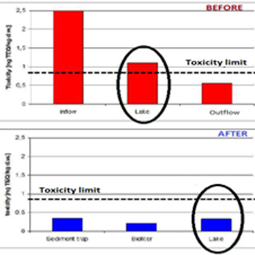
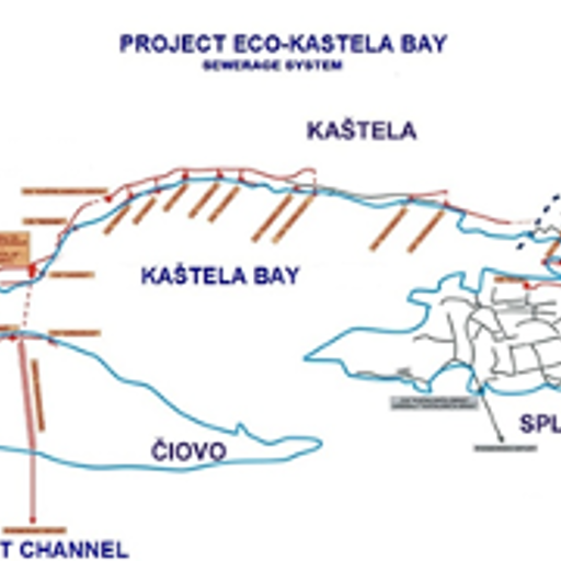
SUSTAINABLE ESTUARINE ZONE MANAGEMENT FOR CONTROL OF EUTROPHICATION, TOXIC BLOOMS AND CONSERVATION BIODIVERSITY IN THE KAŠTELA BAY (CROATIA, ADRIATIC SEA)
- Kaštela Bay is one of the largest bays on the eastern Adriatic coast. Most of the freshwater enters the bay from the River Jadro (average annual inflow of 10 m³/s) and from numerous submarine springs.
- Until 2005, the Bay received high quantities of organic matter and nutrients due to the discharge of untreated sewage waters from multiple rivers especially from the river Jadro.
- ECO Project is the Integral Project of Kaštela Bay Protection and it is one of the widest ecological project in the Adriatic and the Mediterranean Seas.
Demosite Location
Country: Croatia
Contact
- Name: Ivona Marasovic
- Email: marasovic@izor.hr
- Organization: Institute of Oceanography and Fisheries
- Website: www.izor.hr
MATOROVA MIRE (MATOROVANSUO), NORTHERN FINLAND
- A groundwater-fed northern aapa mire (peatland) undergoing restoration to rewet drained areas, enhance carbon sequestration, and restore natural hydrology and biodiversity.
- Enhanced: Carbon sequestration and storage, water quality regulation, and flood moderation are significantly improved through ditch blocking and rewetting. Maintained: Fresh water provision, habitat support, and recreational values are restored and sustained.
Demosite Location
Country: Finland
Contact
- Name: Omar Nimr
- Email: Omar.nimr@oulu.fi
- Organization: University of Oulu, Finland
- Website:
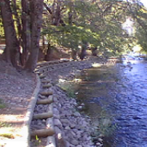
CONSTRUCTED POROUS RIFFLE IN THE URBAN PERIPHERY OF LYON (FRANCE)
- The Yzeron river basin is 147 km2 in area with a population is of 144 000 inhabitants (1 354 000 for Lyon metropolitan).
- Demosites are located N45°44’38.50’’–E4°41’24.49’’ and N45°45’28.24’’–E4°45’04.09’’ on seasonal rivers.
- This project focuses on the enhancement of natural regulating services by increasing local biodegradation capacity of soils and stream sediments to trap and naturally process polluted waters delivered by urban sewage systems.
- The demosites are part of the Field Observatory for Urban Water Management (http://www.graie.org/othu/index.htm) itself included in the European-LTER network (https://data.lter-europe.net/deims/site/czo_eu_fr_030).
Demosite Location

Country: France
Contact
- Name: Pascal Breil
- Email: pascal.breil@irstea.fr
- Organization: IRSTEA- Riverly research unit
- Website: www.irstea.fr
ECOHYDROLOGICAL ANALYSES IN THE LOWLAND RIVER CATCHMENT KIELSTAU, GERMANY, FOR SUSTAINABLE WATER RESOURCES MANAGEMENT AND EDUCATION IN RURAL LANDSCAPES (GERMANY)
- The rural Kielstau catchment (50 km²) is located in northern Germany in a lowland area.
- The Kielstau river’s water quality is strongly influenced by agriculture. Land use is dominated by grain, corn, rape and pasture; 38% of agricultural land is artificially drained (Fig.1).
- The Kielstau river is part of the flora fauna habitat directive (92/43/CEE), and nature conservation areas are used for moderate grazing.
Demosite Location

Country: Germany
Contact
- Name: Britta Schmalz
- Email: bschmalz@hydrology.uni-kiel.de
- Organization: Institute for Natural Resource Conservation, Kiel University
- Website: http://www.uni-kiel.de/
UNDERSTANDING ECOHYDROLOGICAL FLUXES AND STORAGE DYNAMICS IN A DROUGHT SENSITIVE LOWLAND CATCHMENT, NE GERMANY
- characterised by intermittent streams plus including wetland areas
Demosite Location
Country: Germany
Contact
- Name: Prof Dr Doerthe Tetzlaff
- Email: doerthe.tetzlaff@igb-berlin.de
- Organization: IGB Leibniz Institute of Freshwater Ecology & Inland Fisheries, Berlin, Germany
- Website:
SUSTAINABLE WATER RESOURCES MANAGEMENT PLANS IN THE TIBER RIVER BASIN FOR ENVIRONMENT PROTECTION, MINIMUM INSTREAM FLOWS REGULATION AND THE TRASIMENO LAKE ECOSYSTEM PRESERVATION (ITALY)
- The length of the Tiber River is 405 km. Almost 90% of the Tiber River Basin is covered by the regions of Umbria and Lazio. More than 4 million people living in the basin of which 80% in the Province of Rome.
- The basin is mainly characterized by small farms and a leading sector in the Tiber valley is hydropower generation plants concentrated in the Nera River basin.
- Trasimeno Lake is a shallow lake which could host rare species but it is also a well-known touristic area. Since 2006, the lake is part of the international "Living Lakes".
Demosite Location

Country: Italy
Contact
- Name: Stefano Casadei
- Email: casadei@unipg.it
- Organization: University of Perugia
- Website: www.unipg.it
VAL DI CORNIA NEXUS ECOSYSTEM LABORATORY (TUSCANY, ITALY)
- The proposed demonstration site is seated within the Cornia River Mediterranean basin, being the Cornia River and its ecosystem the main hydrological feature. It also includes a rural area with a number of rural municipalities (Campiglia Marittima, Suvereto, Piombino). It also includes the Orti di Bottagone wetland, home for a number of birds (including flamingos). In the plain part of the watershed, the aquifer plays a major role providing the main source of water for human activities and the ecosystems. Very relevant is the interplay between surface water and groundwater, including seawater, being seawater intrusion a main issue in the area.
Demosite Location
Country: Italy
Contact
- Name: Rudy Rossetto
- Email: Rudy.rossetto@santannapisa.it
- Organization: Crop Science Research Center - Scuola Superiore Sant’Anna (Pisa, Italy)
- Website:
SPEULDERBOS: MONITORING OF A HERITAGE THAT PROVIDES ECOSYSTEM SERVICES TO SOCIETY
- A forested groundwater infiltration basin for a major aquifer. Research quantifies how forest management impacts groundwater recharge, a crucial drinking water source for the region.
- Fresh water provisioning is actively enhanced through research on forest management to optimize groundwater recharge. All other services like raw materials, carbon sequestration, and tourism are maintained.
Demosite Location
Country: Netherlands
Contact
- Name: Paul Vermunt
- Email: p.c.vermunt@utwente.nl
- Organization: University of Twente
- Website:
ADAPTATION TO CLIMATE CHANGE THROUGH SUSTAINABLE MANAGEMENT OF WATER OF THE URBAN AREA IN RADOM CITY (POLAND)
- Urban and suburban catchments Ecohydrology approach was implemented in the city area – 112 km2 Ecohydrological solutions have been demonstrated at the level of: * Urban catchment * Rivers (Mleczna, Cerekwianka, Potok Północny) * Urban reservoir “Borki” – major recreational site in Radom City * Small blue-green infrastructure located in several places in the city center
Demosite Location
Country: Poland
Contact
- Name: Tomasz Jurczak
- Email: tomasz.jurczak@biol.uni.lodz.pl
- Organization: UNESCO Chair on Ecohydrology and Applied Ecology, Faculty of Biology and Environmnetal Protection, University of Lodz
- Website: https://www.life.radom.pl/pl/
DEVELOPMENT AND IMPLEMENTATION OF THE ECOHYDROLOGY CONCEPT FOR REDUCTION CYANOBACTERIAL BLOOMS IN A MAN-MADE RESERVOIR (PILICA RIVER CATCHMENT, POLAND)
- The Sulejów Reservoir is a shallow and eutrophic artificial reservoir built in 1974, situated in the middle course of the Pilica River in central Poland.
- The Sulejów Reservoir was used as a drinking water reservoir for the Łódź agglomeration until 2004, and currently, it mitigates flood and drought. It is also an important recreational site (fig.1).
- The Pilica River is the LTSER Platform of the European Long-Term Ecosystem Research Network (LTER-Eu). LIFE+ EKOROB project ‘‘Ecotones for the reduction of diffuse pollution’’ (LIFE08 ENV/PL/000519) are located in the catchment of the Sulejow Reservoir.
Demosite Location

Country: Poland
Contact
- Name: Wojciech Fratczak
- Email: w.fratczak@wp.pl
- Organization: European Regional Centre for Ecohydrology
- Website: www.erce.unesco.lodz.pl
ECOHYDROLOGY BASED URBAN WATER MANAGEMENT AND CITY PLANNING FOR HUMAN HEALTH AND SUSTAINABLE DEVELOPMENT (CITY OF LODZ, POLAND) - SOKOLOWKA RIVER
- Łódź is the second biggest city in Poland with 768,755 inhabitants. There are 18 small streams flowing through Łódź.
- The Sokolowka River flows across the northern part of Łódź and is supplied with about 50 stormwater outlets. The middle and lower section of the river valley has maintained patches of meadows, wetlands and forests (seminatural environment)
- The ecohydrological river rehabilitation took part in three projects: EU SWITCH project (GOCE 018530), EHREK (LIFE08 ENV/PL/000517), Blue-Green Network (City of Łódź).
Demosite Location
Country: Poland
Contact
- Name: Maciej Zalewski
- Email: mzal@biol.uni.lodz.pl
- Organization: European Regional Centre for Ecohydrology
- Website: www.erce.unesco.lodz.pl
SUSTAINABLE ESTUARINE ZONE MANAGEMENT FOR CONTROL OF EUTROPHICATION, TOXIC BLOOMS, INVASIVE SPECIES AND CONSERVATION OF BIODIVERSITY (GUADIANA ESTUARY, PORTUGAL)
- Guadiana River Basin is the 4th largest basin in the Iberian Peninsula: 83% in Spain and 17% in Portugal.
- There exists 1824 dams in the basin. The Guadiana estuary and the coastal areas are affected by the biggest one called the Alqueva dam. It modified the hydrological regime of the estuary and also its ecological functions reducing the ecosystem service of water regulation.
- There are three main protected areas in Guadiana estuary and its floodplains: RAMSAR site, National Reserve, Special Protection Zone (ZPE), Important Bird Area.
Demosite Location

Country: Portugal
Contact
- Name: Luis Chicharo
- Email: luis.chicharo@icce-unesco.org
- Organization: International Centre for Coastal Ecohydrology
- Website:
“ACEQUIAS DE CAREO” OF SIERRA NEVADA (GRANADA, SOUTHERN SPAIN)
- The watersheds of Bérchules, Mecina and Alhorí rivers are placed in Sierra Nevada (Biosphere Reserve and National Park), in southern Spain. An ancestral water and soil management system that enhace recharge is carried out, complining with the precepts of Ecohydrology.
- Thanks to this system, water is better regulated, and the effects of both floods and droughts are lessened, the soil is preserved, ecological diversity is increased, sustainable agriculture and hydraulic heritage are maintained, etc.
- ecological diversity is increased
- Sierra Nevada (Biosphere Reserve and National Park).
Demosite Location

Country: Spain
Contact
- Name: Sergio Martos Rosillo
- Email: s.martos@igme.es
- Organization: Spanish Geological Survey
- Website: http://www.igme.es/
EBRO RESILIENCE STRATEGY
- The demosite focuses on the 325 km middle course of the Ebro River, implementing ecohydrological measures for flood resilience and ecological restoration.
- Constructed wetlands are used as specific measures for feeding and breeding endangered species like the European mink, enhancing local biodiversity.
- The site enhances moderation of extreme events (flood control), waste-water treatment, and habitats for species. These regulating and supporting services are maintained through river and floodplain restoration.
Demosite Location
Country: Spain
Contact
- Name: Bárbara Gutiérrez Teira
- Email: bgutierrez@miteco.es
- Organization: Confederación Hidrográfica del Ebro
- Website:
TAGUS RIVER E-FLOWS: A TOOL FOR INTEGRATED WATER MANAGEMENT, SPAIN
- The river catchment is the scale of water management in the European Union. As the Tagus River is a transboundary river, its management competences are divided into two parts: the Spanish and the Portuguese demarcation. Ecological flows are presented as an Ecohydrology measure that must be implemented in all surface water bodies in the basin to achieve an improvement in the ecological status of the whole.
Demosite Location
Country: Spain
Contact
- Name: Beatriz Larraz
- Email: beatriz.Larraz@uclm.es
- Organization: Catedra del Tajo UCLM-Soliss (Universidad de Castilla-La Mancha, Spain)
- Website:
ADAPTIVE WATER MANAGEMENT IN RESPONSE TO HYDRO-CLIMATIC CHANGE EFFECTS ON ECOSYSTEM SERVICES AND BIODIVERSITY OF THE SWEDISH NORRSTRÖM DRAINAGE BASIN (SWEDEN)
- The Norrström drainage basin is a lowland coastal basin including the capital Stockholm: it is the most densely populated region of Sweden with more than 1,5 million people.
- The basin consists of 4% built-up areas, 36% agricultural and open land, 49% forest, 1,5% wetlands and 9,5% inland waters. Lake Mälaren (fig.1) is the only water supply for Stockholm.
- The Baltic Sea and the Stockholm archipelago are impacted ecosytems.
Demosite Location

Country: Sweden
Contact
- Name: Georgia Destouni
- Email: georgia.destouni@natgeo.su.se
- Organization: Stockholm Univertsity
- Website: www.zoologi.su.se/ekoklim/study_region.html
THE BIRMINGHAM URBAN ECOHYDROLOGICAL OBSERVATORY - MULTI-STRESSOR INTERACTIONS AND THEIR IMPACTS OF ECOHYDROLOGICAL FUNCTIONING
- Urban headwater catchments with mixed land use and multi-stressor impacts.
- Modified urban streams (e.g., River Rea, Bournbrook) under pollution and hydrological pressures.
- Enhanced: Waste-water treatment, extreme event moderation, and habitat provision are improved through wetland restoration, green infrastructure, and pollution mitigation. Maintained: Recreation and education via community engagement.
Demosite Location
Country: United Kingdom
Contact
- Name: Stefan Krause
- Email: s.krause@bham.ac.uk
- Organization: University of Birmingham
- Website:
EDDLESTON WATER RESTORATION (UNITED KINGDOM)
- River system, wetlands and ponds - The Eddleston Water project is a catchmentwide demonstration study designed to investigate the effectiveness of using Natural Flood Management (NFM) tools and measures to reduce flood risk and enhance wetland habitats. Key NFM measures include the creation of engineered high-flow log restrictors, extensive riparian and headwater tree planting, remeandering of once-straightened river channels, and the creation of wetlands and temporary flood storage ponds to achieve its aims. The research is underpinned by a very detailed and extensive hydrological network, alongside groundwater and ecological studies undertaken by the main science providers, University of Dundee and the British Geological Services (BGS), and SEPA itself. The Eddleston has also become a nationally important research platform and the location for many other ecohydrological studies by a wide variety of national and international academic institutes.
Demosite Location
Country: United Kingdom
Contact
- Name: Christopher J Spray
- Email: C.J.Spray@dundee.ac.uk
- Organization: Tweed Forum and University of Dundee
- Website: https://tweedforum.org/our-work/projects/the-eddleston-water-project/
LOS ANGELES RIVER ENVIRONMENTAL FLOWS: BALANCING WATER REUSE AND ECOLOGICAL SUPPORT GOALS IN AN EFFLUENT DOMINATED, URBAN RIVER - USA
Demosite Location
Country: United States
Contact
- Name: Kris Taniguchi-Quan
- Email: kristinetq@sccwrp.org
- Organization: Southern California Coastal Water Research Project
- Website:
Latin America and the Caribbean
LÁCAR LAKE BASIN: IMPROVING LAND USE POLICIES BASED ON AN ECOHYDROLOGICAL APPROACH SAN MARTÍN DE LOS ANDES - NEUQUÉN (ARGENTINA)
- The demosite belongs to the Lácar Lake and Huahum River Basin (Province of Neuquén).
- Several streams and rivers drain from headwaters to the Lacar Lake. The outlet is conveyed as runoff by the Huahum/Valdivia River to the Pacific Ocean. The Pocahullo river crosses the City of San Martín de los Andes (26.000 inh) and drains the East part of the basin, equivalent to 20% of whole surface.
- 700,000 tourists visit National Parks Lanín and Nahuel Huapi. In fact, most of the watershed is under the administration of these two parks.
Demosite Location
Country: Argentina
Contact
- Name: Lorena Laffitte
- Email: laffittesmandes@gmail.com
- Organization: Secretaría de Ambiente - Neuquen
- Website: http://ambiente.neuquen.gov.ar/
RESTORATION OF VICTORIA POND WETLAND HABITAT IN HISTORIC GEORGE TOWN, GREAT EXUMA FOR SUSTAINABLE MANAGEMENT TO CONTROL POLLUTION AND ENHANCE NEAR SHORE FISH HABITAT (BAHAMAS)
- Great Exuma is the largest island in the Exuma island chain, with just fewer than 8,000 people living on the island in six major settlements. George Town is the largest and oldest settlement, located at the southwestern shore of Elizabeth Harbour. Victoria Pond is the largest wetland complex in Elizabeth Harbour;
- Ecosystem services are linked to coastal ecology – protection of near-shore environment to support fish production and reduce flooding in George Town – degraded by the destruction of coastal wetlands (mangrove habitats).
- There is one on-going program involving the restoration of Victoria Pond called Ramsar Caribbean Wetlands Initiative.
Demosite Location
Country: Bahamas
Contact
- Name: John A. Bowleg
- Email: wcjbowleg@wsc.com.bs
- Organization: The Water and Sewerage Corporation of the Bahamas
- Website: http://www.wsc.com.bs/
ECOHYDROLOGY OF THE TAJZARA LAGOONS AND ITS IMPORTANCE IN THE DEVELOPMENT OF REGIONAL CLIMATE CHANGE INDICATORS
- The Tajzara Lagoons, located in the department of Tarija, Bolivia, are a group of bodies of water located at an altitude of aprox. 3,700 meters above sea level, and represent a RAMSAR site of Bolivia. They are located on the semi-arid plateau of the Bolivian low or sub-Andean Highlands, sorrounded by mountains peaks that reach 4,000 meters. The region has a cool and dry climate, with temperature fluctuating significantly between day and night.
Demosite Location
Country: Bolivia
Contact
- Name: Mario Carmelo Gamarra Mendoza
- Email: mariogamarra@uajms.edu.bo
- Organization: Water Research Center & Juan Misael Saracho Autonomous University
- Website:
ECOHYDROLOGY AS NATURE-BASED SOLUTION FOR A TROPICAL RIVER BASIN IN CENTRAL BRAZIL
- The total area of the Upper Araguaia basin is 50,000 km², with a population of around 1 million inhabitants, directly influencing the economy of five Brazilian states, which makes the territory of the Upper Araguaia watershed extremely important. The region has incalculable ecological, tourist, socioeconomic and cultural importance. Species that depend on large native areas to survive, such as the jaguar, have an important environment in the Upper Araguaia to maintain, reproduce and disperse and is considered one of the rivers with the largest fish biodiversity and fish stock in Brazil. The main channel of the Upper Araguaia River and its contributors are an essential source for supplying 25% of the territory of the state of Goiás and 8% of its population, for example. In addition, the ecosystem services of the Cerrado, the predominant biome in the region, are fundamental to produce water to different water users and the environment.
Demosite Location
Country: Brazil
Contact
- Name: Sérgio Nésio
- Email: sergio.nesio@institutoespinhaco.org.br
- Organization: Instituto Espinhaço
- Website:
PROGRAM SEEDING FORESTS, HARVESTING WATER IN THE RIO SANTO ANTÔNIO IN THE MUNICIPALITY OF CONCEIÇÃO DO MATO DENTRO – MINAS GERAIS (BRAZIL)
- The micro hydrographic basin of the upper Santo Antônio River is located in a territory of 32,280 hectares and has as its centrality the main water courses and their areas of water recharge, from the main source to the catchment area for public supply, already in the city of Conceição do Mato Dentro. The Santo Antônio river stands out for having several areas of drainage headwaters located in the Serra do Espinhaço Biosphere Reserve, which in turn provide peculiar characteristics in relation to the other units of the Doce river basin. The Santo Antônio river basin has a direct and indirect relationship with a population of around 190,000 people and covers the following municipalities: Açucena, Alvorada de Minas, Antônio Dias, Belo Oriente, Braúnas, Carmésia, Conceição do Mato Dentro, Congonhas do North, Dom Joaquim, Dores de Guanhães, Ferros, Guanhães, Itabira, Itambé do Mato Dentro, Joanésia, Materlândia, Mesquita, Morro do Pilar, Naque, Passabém, Sabinópolis, Santa Maria.
- A particularity of the micro hydrographic basin of the upper Santo Antônio River is the presence of vegetation characterized as highland fields and rocky fields, in addition to savannah vegetation, which clearly marks the transition between the domain of the Atlantic Forest and the domain influenced by the largest basin altitudes when approaching the Cerrado biome.
Demosite Location
Country: Brazil
Contact
- Name: Sérgio Nésio
- Email: sergio.nesio@institutoespinhaco.org.br
- Organization: Instituto Espinhaço
- Website:
CEHUM: SCIENCE, TECHNOLOGY, EDUCATION AND MANAGEMENT TO INFORM EVIDENCE-BASED SOLUTIONS FOR WETLAND CONSERVATION.
- The Río Cruces wetlands are restored ecosystems supporting rich biodiversity, water purification, carbon storage, and education, integrating community engagement and sustainable management within Valdivia’s temperate rainforest landscape.
- The Valdivia and Cruces Rivers form a dynamic hydrological system connecting lakes and wetlands, providing freshwater, habitat, flood regulation, and essential ecosystem services for southern Chile’s biodiversity.
Demosite Location
Country: Chile
Contact
- Name: Ignacio Rodriguez-Jorquera
- Email: ignacio.rodriguez@uach.cl
- Organization: Centro de Humedales Río Cruces, Universidad Austral de Chile
- Website:
QUEBRADA PARQUE: URBAN CREEK AND WETLAND RESTORATION BASED ON THE MANAGEMENT OF QUEBRADA HONDA AS AN ECOPARK WITH AN ECOHYDROLOGICAL APPROACH IN PUERTO VARAS (CHILE)
- Peak flows are increasing due to ongoing urban growth in the upper basin, hence the need to increase the wetland’s torage capacity to prevent flooding. The solution has been designed to control the 10-year storm flow with green infrastructure (vegetated parapet around the wetland’s perimeter) and safely evacuate the 100-year storm flow through a spillway into the municipal rainwater network.
- Peak flows are increasing due to ongoing urban growth in the upper basin, hence the need to increase the wetland’s storage capacity to prevent flooding. The solution has been designed to control the 10-year storm flow with green infrastructure (vegetated parapet around the wetland’s perimeter) and safely evacuate the 100-year storm flow through a spillway into the municipal rainwater network.
Demosite Location
Country: Chile
Contact
- Name: 1 Camila Teutsch
- Email: camila@patagua.cl
- Organization: PATAGUA
- Website: https://www.patagua.cl/
INTEGRATED WATER GOVERNANCE FOR SUSTAINABLE WATER RESOURCES MANAGEMENT AND EDUCATION IN RURAL AND PERIURBAN LANDSCAPES IN TEUSACÁ RIVER BASIN (COLOMBIA)
- The Teusacá Sub-basin (356 km2) is located in the southern sector of the Eastern Cordillera, close to Bogotá (9 million people), Teusacá River (43 miles - 67 km - length) rises in Laguna del Verjón inside a protected Ecological Park and flows into the Bogotá River, one of the most polleted rivers inthe country.
- Water regulation by reduction of peak-flows when heavy storms and maintain baseflow when dry seasons within the whole system. Water quality improvement with biofiltration. The river crosses 6 municipalities and recieves sewage from different economic activities including: cattle, agriculture, industry, houses and schools
- The proposed demosite includes the entire watershed in order to analyze the impacts to the implementation of a series of ecohydrology solutions that will be incorporated over time to solve different problems related to the multiple land uses.
Demosite Location

Country: Colombia
Contact
- Name: Lina Zuluaga
- Email: direcciongrancuenca@progresaresp.com
- Organization: Progresar ESP
- Website: https://progresaresp.com/
MODELLING AND IMPLEMENTATION OF ECOHYDROLOGICAL RESTORATION ALTERNATIVES AT THE ZAPATOSA WETLAND COMPLEX (ZWC) IN COLOMBIA
- Wetland complex under high anthropic pressure; it includes the Zapatosa wetland, which is the largest freshwater wetland in Colombia (310 km2), located on the Cesar River Delta before it discharges into the Magdalena River.
- Serves as a supply of food (fish), raw materials (wood and fiber), fresh water, cultural services related to tradition and folklore, habitats for diverse fauna and flora, flow buffering, and climate regulation.
- The ZWC was designated a Ramsar site in 2018 and a regional protected area through the figure of the Regional District of Integrated Management (RDIM) in December 2019. It is also a conservation area in the Water Basin Development and Management Plan (POMCA, its Spanish acronym) of the lower César River.
Demosite Location
Country: Colombia
Contact
- Name: Beatriz Hernández
- Email: bhernandez@natura.org.co
- Organization: Fundación Natura Colombia
- Website: https://natura.org.co
A METHODOLOGY TO ESTIMATE COMPENSATORY RUNOFF IN COSTA RICA, RANA-ICE STUDY
- The area is divided into three basins: Reventazon River (a), Savegre River (b) and Térraba River Basins (c).
- The Térraba River Basin corresponds to 10% of the total area of Costa Rica. All are important for consumptive and nonconsumptive uses, especially for transport, cattle and fishing.
- There are many conservation areas like La Amistad Conservation Area and National Wetland Terraba - Sierpe.
Demosite Location

Country: Costa Rica
Contact
- Name: Anny Chaves Quiros
- Email: achaves@ice.go.cr
- Organization: Instituto Costarricense de Electricidad
- Website: www.grupoice.com
PELICAN BAY WATERSHED, SANTA CRUZ, GALAPAGOS (ECUADOR).
- In the Pelican Bay basin is the most important human accentuation in Galapagos (93.5% of the canton and 57.3% of the province). It has 5 vegetation zones influenced by precipitation and altitude
- The main water’s source is groundwater, highly susceptible to contamination by anthropic activities. The population and tourist increase induces the over-exploitation of aquifers.
- UNESCO Natural Heritage Site (1978) and Biosphere Reserve (1985)
Demosite Location

Country: Ecuador
Contact
- Name: Marco Albarracin
- Email: marcoalbarracin@gmail.com
- Organization: Ecohydrological Foundation
- Website: https://www.linkedin.com/in/marco-albarracin-5bb4a4b/
RECOVERING THE ANCESTRAL WATER SYSTEM OF LOS PALTAS WITH ECOHYDROLOGICAL APPROACH TO SUPPLY WATER TO THE CITY OF CATACOCHA IN SOUTHERN ECUADOR
- The San Pedro Mártir microbasin is located in the Paltas canton, in southern Ecuador. It has a total surface of 31 km2 and provides 70% of water to the city of Catacocha.
- The ancestral hydrological system of the Paltas based on lentic wetlands (albarradas) and small dams (tajamares) to recharge the aquifers was abandoned by the Spanish colonists and local people to use the land for livestock and agriculture.
- The restauration of the ancestral knowledge and watershed management, has allowed to improve the water supply from 1 to 6 hours per day.
- Transboundary Biosphere Reserve (Ecuador - Peru) UNESCO Forests of Peace Catacocha is a Cultural Heritage of Ecuador. The management model won the First Place of the Green Award from the Ecuadorian Development Bank in 2017.
Demosite Location

Country: Ecuador
Contact
- Name: Marco Albarracín
- Email: marcoalbarracin@gmail.com
- Organization: Fundación Ecohidrológica
- Website: https://www.linkedin.com/in/marco-albarracin-5bb4a4b/
SOWING, HARVESTING AND REUSING WATER FOR SUSTAINABILITY STRATEGIES. PROJECT CODE: PG13-PY24-07
- This demosite focuses on the sustainable management of the Manglaralto river basin. It uses a technical-artisanal dam for aquifer recharge and green filters for wastewater treatment to improve water security in a semi-arid coastal region.
- The project utilizes the intermittent Manglaralto River, employing an artisanal dam ("tape") to slow flow, enhance infiltration into the riverbed, and recharge the underlying coastal aquifer.
- The site addresses saline intrusion into the coastal aquifer. Interventions like the recharge dam help maintain freshwater levels, protecting adjacent coastal ecosystems from contamination and supporting local biodiversity.
Demosite Location
Country: Ecuador
Contact
- Name: Emily Nicole Sánchez Zambrano
- Email: emnisanc@espol.edu.ec
- Organization: Manglaralto River-Aquifer System, Santa Elena (Ecuador), Escuela Superior Politécnica del Litoral (ESPOL)
- Website:
INTEGRAL RAINWATER HARVESTING SYSTEM IN LA REINA, EL SALVADOR
- The project operates in a 2.9 km² micro-basin, using infiltration ditches, reservoirs, and living barriers to enhance water retention, aquifer recharge, and climate resilience in a drought-prone region.
- Two reservoirs with a total capacity of 5,000 m³ store rainwater, regulate flow, support local biodiversity, and provide water for hydroponic fodder and livestock in La Reina.
- The demosite enhances Fresh Water provision, Erosion Prevention, and Habitats for Species. It also maintains Local Climate Regulation and Moderation of Extreme Events like floods and droughts.
Demosite Location
Country: El Salvador
Contact
- Name: Aaron Enrique Estevez Flamenco
- Email: aaron.estevez@asa.gob.sv
- Organization: Salvadoran Water Authority (ASA)
- Website:
ÁREA NATURAL PROTEGIDA LAGO DE TEXCOCO
- Part of the Panuco Hydrological Region, essential for flood control and aquifer recharge in the Valley of Mexico.
- Intermittently flooded lake wetland with saline soils, vital for migratory birds and hydrological regulation.
- The demosite enhances ecohydrological processes by constructing artificial wetlands, restoring natural water bodies, and applying nature-based solutions for wastewater treatment, flood control, and habitat regeneration.
Demosite Location
Country: Mexico
Contact
- Name: Adrián Pedrozo Acuña
- Email: director_general@tlaloc.imta.mx
- Organization: Instituto Mexicano de Tecnología del Agua
- Website:
EL SMEHP CHILLCA - SISTEMA DE MONITOREO ECOHIDROLÓGICO PARTICIPATIVO (PARTICIPATIVE ECOHYDROLOGICAL MONITORING SYSTEM), PERU
- Upper part of the Chillca and Pitumarca river basin (one of the main basins of the better known Vilcanota-Urubamba watershed), in an area of more than 25,000 hectares and between altitudes of about 4,200 and 6,384 m a.s.l
Demosite Location
Country: Peru
Contact
- Name: 1 Jan R Baiker
- Email: jbaiker@gmail.com
- Organization: Asociación para la Conservación y Estudio de Montañas Andinas Amazónicas (ACEMMA)
- Website: www.acemaa.org
THE “AMUNAS” OF THE CARHUAYUMAC MICRO-BASIN, WATER SOWING PRACTICES OF SAN PEDRO DE CASTA IN HUAROCHIRI, LIMA. PERU.
- The hydrographic unit corresponds to the Carhuayumac micro-basin with an area of 58 square kilometers, which is embedded in the Santa Eulalia sub-basin with a total area of 1077.38 square kilometers, which in turn represents 30.75% of the total area of the Rímac basin, major siver supplying water to Lima.
Demosite Location
Country: Peru
Contact
- Name: Jose Antonio Fernandez Lopez-Lavalle
- Email: contacto@aquafondo.org.pe
- Organization: Fondo de Agua para Lima y Callao – Aquafondo
- Website: https://aquafondo.org.pe/